Human Footprint Mapping & Monitoring
Human Footprint Inventory
The ABMI’s Geospatial Centre produces a comprehensive Human Footprint Inventory for the entirety of Alberta. This data set dates back to 2000 and is now updated annually to reflect changing human footprint condition across Alberta. The current Human Footprint Inventory contains 117 feature types and 20 individual sublayers including seismic lines, harvest areas, roads, and pipelines.
Visit the Human Footprint data download page to download and explore our Human Footprint data or view our Human Footprint Webinar to learn more about the program.
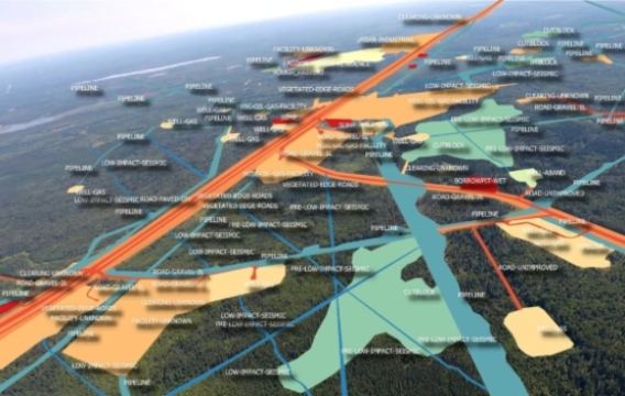
An example of the interpretation and labeling of human footprint features (left) and the human footprint inventory over all of Alberta (right).
Enhanced Human Footprint
The Human Footprint team has also produced an enhanced human footprint inventory for the Oil Sands Region. This has all the same data as the wall-to-wall inventory but with more detailed information such as age attribution, light pollution, and information on post-disturbance revegetation.
Human Footprint Monitoring - Harvest Area & Well Pad Regeneration
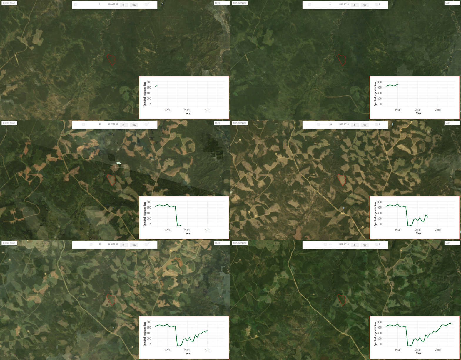
The ABMI’s Geospatial Centre also develops novel methods to monitor the recovery/regeneration of human footprint features. Using the Landsat historical imagery archive (1984 - present) the ABMI attempts to track and measure the spectral regeneration of human footprint features such as harvest areas, mines and well pads. This information is added to our current Human Footprint Inventory to get a measure of vegetation recovery for each individual feature.

An example spectral regeneration curve of a harvest area cut in 1995.
Landcover Mapping & Monitoring - The ALPHA-S Program
The Advanced Landcover Prediction and Habitat Assessment-S (ALPHA-S; S for satellite) team uses open access Earth observation data and machine learning to map and monitor “natural” (non-human footprint) areas in Alberta. To learn more about the ALPHA program check out our ALPHA-S webinar on Youtube, visit the ALPHA products page on the ABMI’s data download, or visit our publications page under subject area “remote sensing”.
Wetland Mapping
The ALPHA-S team produces products that help to map and monitor wetland across Alberta. The ALPHA-S team uses convolutional neural networks to help produce the ABMI Wetland Inventory which maps wetland class across Alberta’s landscapes with a 10 m resolution (DeLancey et al., 2020). The team also tracks wetland flooding dynamics with time-series Synthetic Aperture Radar (SAR) data stacks and tracks long term changes to wetlands using historical satellite imagery.

The ABMI wetland inventory
Upland Mapping
In addition to the wetland mapping and monitoring, the ALPHA-S team uses openly accessible earth observation data to produce up to date information on Alberta upland habitat areas. This includes forestry information such as, canopy closure, and percent deciduous, and information on shrubland/grassland habitats. With information on upland, wetland, and human footprint areas the ABMI aims to produce a comprehensive landcover data set for all of Alberta.
Algal Bloom Monitoring
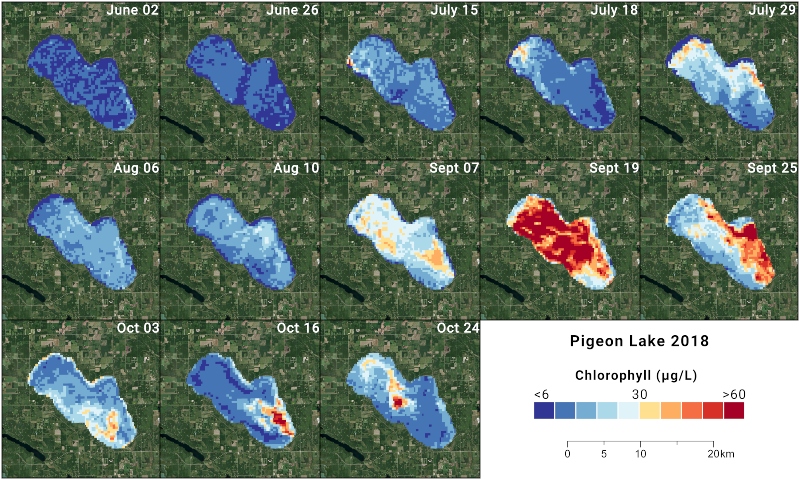
We use a near-real-time stream of satellite data to track algal blooms and cyanobacteria pigments in select lakes across Alberta. This data can provide chlorophyll and other pigment estimates across whole lakes, and provide quality data for lake communities to manage water quality.

Remote sensing measure of chlorophyll A concentration in Pigeon Lake during 2018.
Detailed & High Resolution Landcover Mapping - The ALPHA-SG Program
The ALPHA-SG program builds on the ALPHA-S and Human Footprint programs by providing more detailed information on landcover and human footprint. This is accomplished through the use of available airborne data and LiDAR usually in the form of point cloud datasets (e.g., photogrammetric point clouds for airborne data). With this data we are able to pick out individual tree measurements , extract and provide highly detailed information on vegetation, wetlands and the revegetation state of human footprint features.

An example of photogrammetric point cloud data used in the ALPHA-SG program.
More questions? Feel free to contact:
Dr. Cynthia McClain
Director, Geospatial Centre
cmcclain@ualberta.ca

